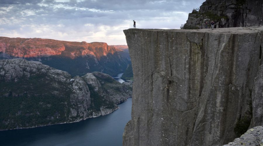
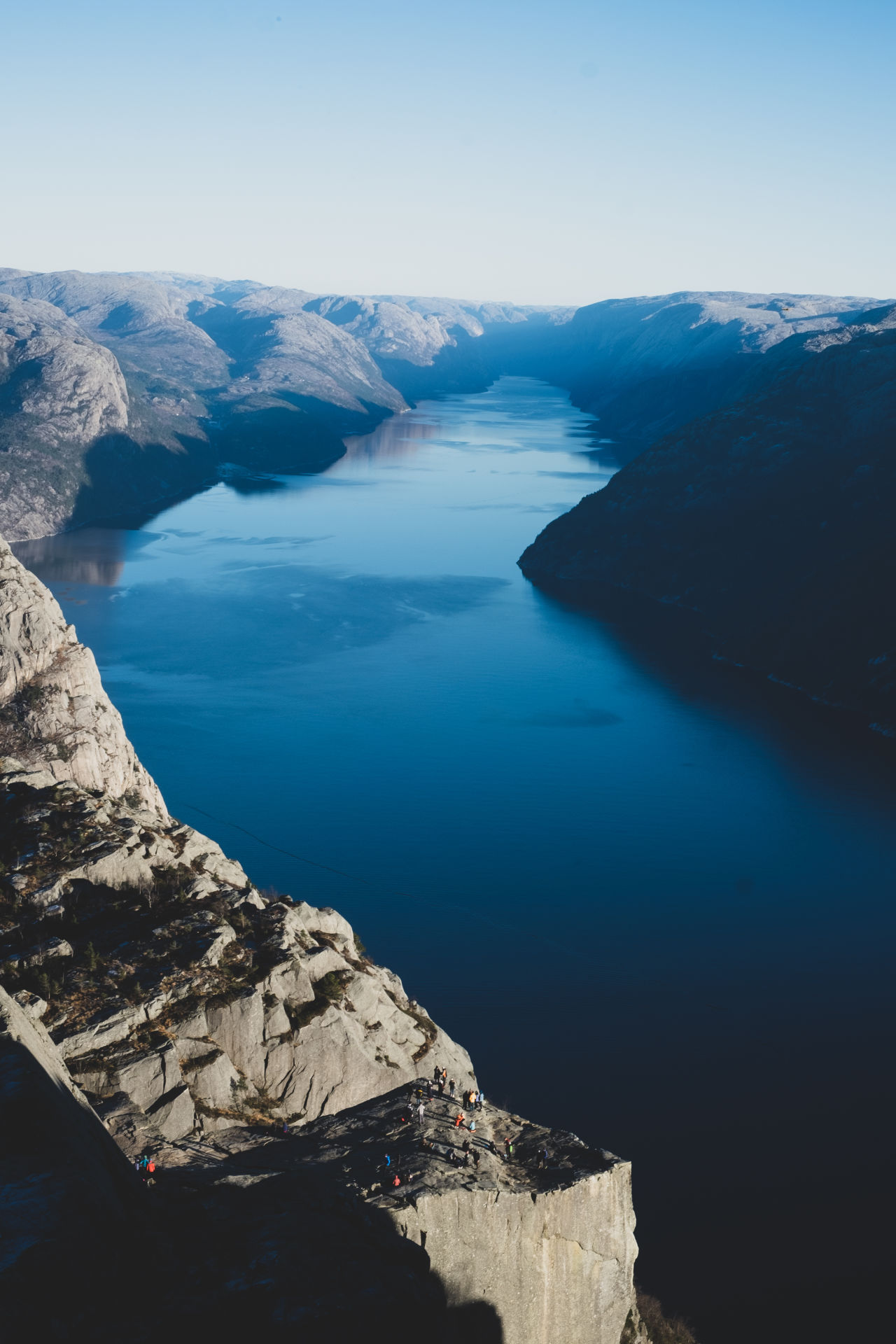
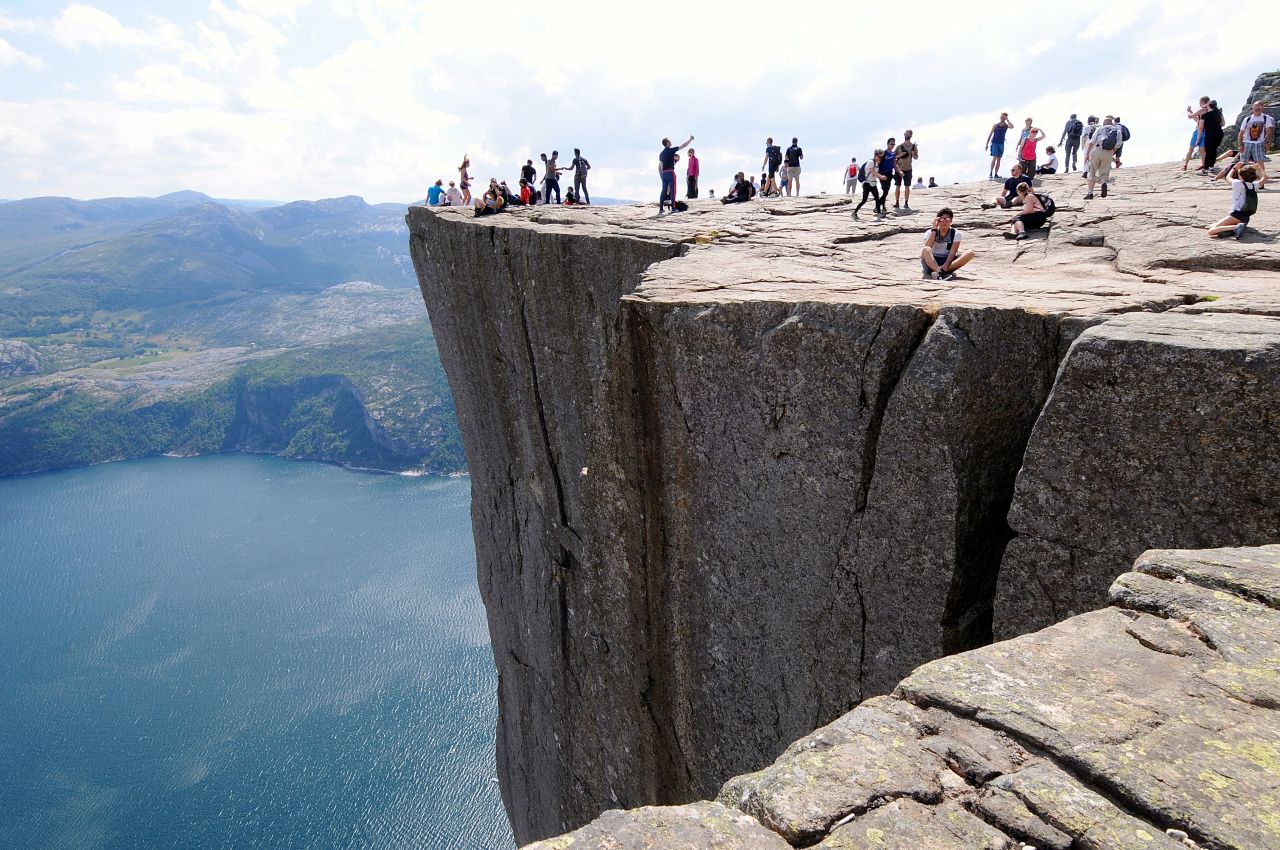
Preikestolen
Adkomst med egen bil
Ryfylketunnellen forbinder Stavanger med Jørpeland. Parkering ved Preikestolen Fjellstue. Avgift.
Adkomst med kollektivtransport
Om turen
- OmrådeRyfylke
- TypeFottur
- GraderingMiddels
- Lengde og varighet4,1 km2 timer, 30 minutterTuren går tur/retur samme vei
- SesongHele året
For English, see below
Turen fra Preikestolen Fjellstue til Preikestolen er en av landets mest gåtte fjellturer – ca 300 000 mennesker tar turen ut på det svimlende fjellplatået hvert år. Turens mål er utkikksplatået mot fjorden, men med på kjøpet får du en flott tur gjennom frodig Vestlandsnatur med idyllisk skogsterreng og flere flotte utkikkspunkter underveis.
Om du vil unngå store menneskemengder og kødannelse på stien bør du besøke Preikestolen utenom “rush-tidene”. Midt på dagen, særlig i helgene, og i månedene juni-september er de travleste tidspunktene. Om sommeren kan det anbefales å utnytte de lange dagene og legge turen til kvelden. Det er færre folk i løypa etter kl. 15:00 – og om morgenen før kl 09:00. Ha alltid med riktig utstyr og ta trygge valg i fjellet dersom du velger å gå om kvelden eller utenom sommersesongen. Bli med på guidet tur om vinteren, til soloppgang eller på umerkede løyper (se Outdoorlife). Dersom du besøker Preikestolområdet i høysesongen og foretrekker mer private naturopplevelser kan du velge én av de mange andre turløypene i nærområdet. Se forslag under.
RUTEBESKRIVELSE:
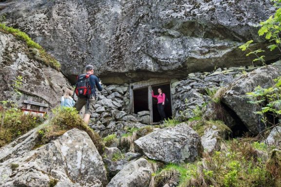
Selve gåturen ut til Preikestolen er unnagjort på under to timer for dem som er vant til å gå i terreng. Sherpaer fra Nepal har lødd opp stein det meste av stien for å skåne terrenget og lette turen. Likevel er det kupert og ulent det meste av turen. For barn og utrente turgåere vil vi anslå å bruke mellom to til tre timer ein vei uten pause. Høydeforskjellen er 330 meter og distansen 4 km. Vel framme venter et så godt som flatt platå på 25 x 25 meter, 604 moh. Stien er betydelig oppgradert. Den er laget bredere og flere plasser er det lødd opp stein trapper. Ikke undervurder turen, den er lengre enn du tror. Husk å legg inn tid for returen også. Kombiner gjerne turen med et måltid eller en overnatting på Preikestolen Fjellstue. Gjester på fjellstua har gratis parkering.
De fleste går turen i sommerhalvåret, men på vinteren kan man få en særegen tur og en flott opplevelse selv om stien er dekket med snø og is, og værforholdene kan være utfordrende. Det er vanligvis ikke skiføre, men det tråkkes som oftest sti i snøen slik at det er greit å gå til fots. På toppen er det alltid mye mer vindfullt og kaldere enn på parkeringplassen, så ta med utstyr og klær for å takle forholdene. Husk at dagene er korte om vinteren, og beregn ekstra tid da det kan være tyngre å gå. Brodder og annet utstyr kan leies på Preikestolen fjellstue.
Parkering: Parkeringsplass for 1000 biler ved Preikestolen Fjellstue mot avgift. Toaletter og kiosk.
Løype: Tilrettelagt og merket sti. Telting og bålbrenning frarådes. Lengde 7 km. Høydeforskjell 350 m. Terreng: småkuppert. 3-4 timer.
Kart: Turkart Preikestolen 1: 25 000. Turkart Lysefjorden 1: 50 000.
Turgåere oppfordres til å holde seg til oppgått/tilrettelagt sti for å unngå unødig slitasje i terrenget. Om mulig, forsøk å unngå å gå turen etter store nedbørsmengder. Følg alltid prinsippet om sporløs ferdsel i naturen – etterlat deg ingenting annet enn fotspor.
Alternative turer i Preikestolområdet
- Moslifjellet – gjennom barskt høyfjellsterreng, langs morener fra istiden til vid utsikt fra 718 moh. Samme start som stien til Preikestolen men ta av ved skilt på det første platået.
- Vatnarindane – flott tur som byr på troll, istidsgeologi, bær, sopp og yrende fugleliv. Stien går vestover fra Preikestolen Fjellstue.
- Gryteknuten – en lettgått 2-timerstur som gir panoramautsikt fra 456 moh. Turen starter ved Preikestolen Fjellstue.
- Hatten – 2 timers tur som gir fantastiske utsyn over Lysefjorden. Parkering i Botsheia.
- Hesten i Rogalands største naturreservat gir vidt utsyn over Ryfylkeøyene, Høgsfjorden og Ryfylkeheiene. Merket løype til Hesten fra Lerang, Botsheia og Erlandsdalen. Parkering Lerang og Botsheia. 2-3 timer.
- Sokkaknuten – 2 timers topptur like ovenfor munningen til Lysefjorden. Parkering: Lysefjord hyttegrend, Oanes.
- Sollifjellet – se Preikestolen forfra. Turen starter fra Skrøyla, på den andre siden av Lysefjorden.
_____________________________________________________________________________
ENGLISH
The hike to the mountain plateau Preikestolen (Pulpit Rock) is one of Norway’s most famous hikes. The marked trail takes you through varied nature and landscapes, sometimes bearing steep uphill, partly on stonebuilt steps and leads you all the way out onto the spectacular viewpoint 604 meters above the Lysefjord.
Grading: Demanding
To avoid the crowds – avoid peak hours. The trail is busiest mid-day, weekends and in the summer months June – September. In the summer you can take advantage of the bright summer evenings and hike later in the day/evening. There are fewer people on the trail after 4pm. Beware to always bring appropriate equipment and make safe choices when hiking. If you visit outside the summer season, have little experience hiking or want a unique experiences in the winter, at sunrise or make new friends and learn something new – join a guided tour (see Outdoorlife ).
If you have some hiking experience and prefer a more private experience in nature with less people, discover the less known trails to other great lookout points in the area. See alternatives listed below.
PREPARATION
Before you leave the parking area, make sure you fill up all you need for a long day outdoors. There is a public toilet, a kiosk (in season) and other facilities at the main parking. Once you set off, there is nothing but nature and your fellow hikers.
During winter, the trail is covered with snow an ice and weather conditions may be challenging. However, with the right equipment, a winter experience to Preikestolen may be rewarding. Crampoons are highly recommended during winter, it may be rented at the mountain lodge. The weather is always much more severe at the top than at the parking, so prepare with wool underwear and wind- and waterproof outer layers, and sturdy boots. Clothes and boots are also for rent at the lodge. Beware of early nightfall, and make sure that you return in time to reach the parking well ahead of the darkness.
FOLLOW THE RED “T”
The trail is marked with the Trekking Association’s red Ts. Signs show the distance remaining forward to the Preikestolen plateau and back to the parking.
TAKE-OFF
Whether you have just torn yourself away from breakfast at Preikestolen Mountain Lodge, or you have just arrived with car or bus from Stavanger – the first steps towards Preikestolen can be quite a shock. Surrounded by the dewy smell of pine forest, rocks and adventure, you may be gasping for your breath. The trail from the parking lot is the steepest part of the whole hike, but the climb is done in five minutes. On your way uphill, you hear a mixture of bird song, tongues from all corners of the world and the clicking of American stilettos on grey granite. Plastic bags are occasionally a sight as normal as backpacks.
INTO THE WILD
When you reach the first mountain plateau you should turn around. Deep down below, you’ll see Preikestolen Mountain Lodge and Lake Refsvatnet with its excellent bathing conditions and water sport activities. As you lift your gaze, you may catch a glimpse of Stavanger city peninsula in the far distance – beautiful! If you have a weak mind, this is the moment of truth: Right beside the track a zip-line – the second longest in Norway – offers an easy flight back to the starting point! An amazing experience – which will be the perfect finishing touch after you have taken the trip to Preikestolen, so save the airy hovering tour for the way back!
WAYMARKS
The path that goes on from the viewing point is a wide and clear path through a landscape of pine trees and the occasional polished rock. No other tourist path in Norway is better marked than this one. On your way to the top you pass, among much other, 40 distance markers telling you how far you have left until you reach Preikestolen, but also the distance back to the parking lot. This makes it easy to divide both powers, food and refreshment breaks. Should you get so captured by the nature and your surroundings that you manage to go astray from the path, do not despair: Most missteps are marked with great stop signs that says: “STOP – you have now left the path to Preikestolen”.
CROSSING THE MOOR
The elevation rises steadily. After all, you are climbing 350 meters in before you spot the blue waters of the Lysefjord far beneath you. Around you the sheltered forest coves for crooked birch and the nature renews its wonders behind each turn of the path. Even the marshes is passed with dry feet, you just walk right through on wide pavements made of tree, high enough over mud and swamp to keep your feet as dry as ever.
THE NEVERLANDS RAVINE
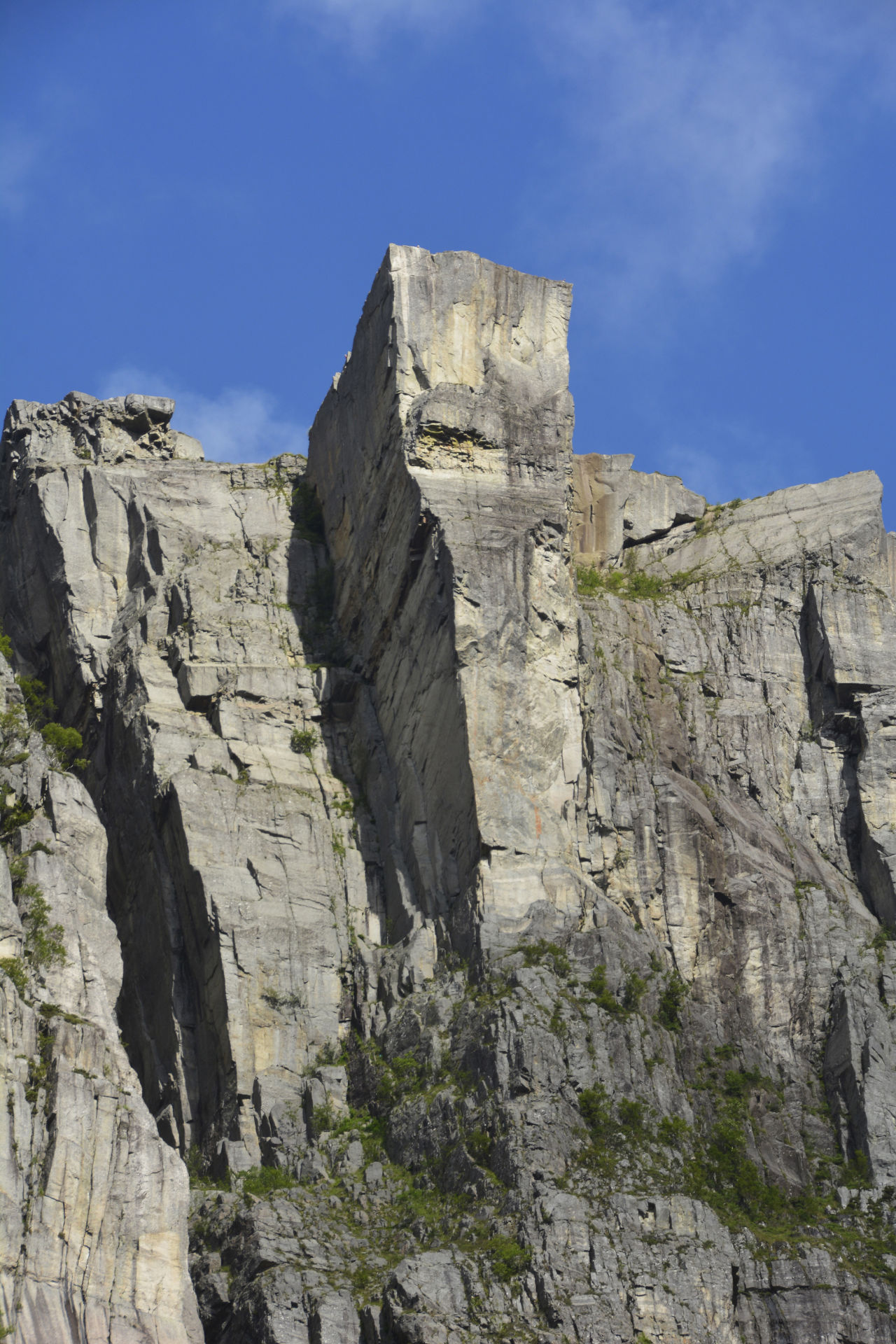
You have already conquered half the distance to Preikestolen. In front of you lies a ravine; Neverdalsskaret. Until just recently, this could be called a potential bone breaker; a steep rock scree filled with slippery blocks of rock that on a rainy day could be a threat to public health, health care and the sparetime of local rescuers. But this is not today. The last year this ravine have been transformed to a rock screes answer to Taj Mahal – in the figure of a granite stairway which your foot and, not least, your eyes will consider a sight of beauty. Nepalese sherpas have carefully placed giant blocks or rock with cleverness, manual power and ancient knowledge at hand. It is a judiciously intervention in nature made to protect vulnerable terrain and staggering tourists towards mutual destructions.
ROCK AROUND THE FJORD
As you take your last steps through the ravine of Neverdalsskaret, most altitude meters towards Preikestolen have been climbed, and are now behind you. Are you one of those who have realized that the area of Lysefjord can offer you several nature attractions and experiences, and not just Preikestolen? Now you can walk away from the crowded path towards Preikestolen, and instead embark on your hut-to-hut hike along the Lysefjord. If this is your path, look forward to a first class hike through world class nature, with attractions like Hengjandenibba, the mountain farm of Bakken, the unique village of Lysebotn, the dizziness of Kjerag, and the challenge of the 4444 steps of Flørli.
Aqua landscape
But, back to the Preikestolen route: From the top of the ravine, you follow the rock paved path. Here and there you will get a good view of both fjord and mountains, then, up the last stone stairway and through a lush birch grove, lies the perfect place for a rest: Polished rock surrounded by three small ponds. During a sunny day these small lakes will be heated quickly, so toss away your clothes and enjoy a delightful bath!
LAST PUSH
Refreshed and rested from your bath break, you take on the final stage on getting to your goal; Preikestolen. Just after passing the last pond, you reach a path cross. If you take to the right, you’re taking a path leading to Preikestolen from behind, through a smaller height, and then down a steep slope. Many prefer this alternative route on their return, for that picture perfect overlook of the plateau on the way back. Taking the main path straight ahead moves you through a more gentle terrain. But after some hundred meters, your pulse will rise: You can spot the Lysefjord! The majestic fjord that splits the bedrock in two. If you look to your left you can on clear days see all the way to Lysebotn, the innermost village of Lysefjorden, surrounded by steep cliffs – amongs them Kjerag. If you keep walking and follow the path you’re on to the right, the climax awaits you: Preikestolen!
THE ABYSS
About 604 vertical meters above the Lysefjord, the plateau of Preikestolen is hanging, slightly swaying beyond the abyss. An amazing view as you walk the final meters of the path, which is replaces by a tingling feeling you might never have experienced before, as you step on to the great granite block with nothing but empty air on three of its sides. Enjoy!
THE REWARD
As you hike the same path back to Preikestolen Mountain Lodge and the parking area, you may chooce to “fly” the last bit – hoovering in a 350 meter long zip-line.
ENJOY YOUR HIKE!
Alternative hikes in the area
Information in the links below is in Norwegian, but maps are available.
- Moslifjellet – through highland landscapes, along moraines from the ice age to a peak 718 meters above sea level with splendid views. The first part of the trail to Moslifjellet follows the trail to Preikestolen, but takes a different route at the first plateau.
- Vatnarindane – a nice hike featuring a troll(!) ice age geology, wild berries, fungi and rich birdlife. Same starting point as the hike to Preikestolen (parking by Preikestolen Fjellstue), but this adventure goes West rather than East.
- Gryteknuten – a fairly easy 2-hour hike giving you panoramic views from 456 humble meters above sea level. Starts by Preikestolen Fjellstue.
- Hatten – a 2-hour hike offering gorgeous views and great photo spots above the Lysefjord. NB not the same starting point as Preikestolen; parking in Botsheia.
- Hesten – a small but mighty peak in the county’s largest nature reserve, offering panoramic views. Marked trail to Hesten from Lerang, Botsheia and Erlandsdalen. NB not the same starting point as Preikestolen; parking in Lerang or Botsheia.
- Sokkaknuten – a 2-hour hike just above the Lysefjord bridge, with great views of the fjord mouth. NB not the same starting point as Preikestolen; parking at Lysefjord hyttegrend, Oanes.
- Sollifjellet – admire Preikestolen from across the fjord! This hike starts from Skrøyla, on the other side of the fjord (a 20 min car drive from Forsand).
Hikers and every enjoyer of nature are encouraged to stick to the marked trail to avoid unnecessary damage and wear of the landscape. If possible, svoid hiking the day after heavy rainfall. Leave nothing behind but your own footsteps.
More info about getting to, and hiking Preikestolen at Preikestolen 365.